An article published today in the Los Angeles Times contains several fascinating details, including scenes of researchers from the Southern California Earthquake Center digging trenches into land surrounding the San Andreas fault. 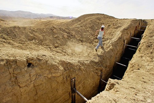 [Image: Photo by Ricardo DeAratanha, courtesy of the Los Angeles Times].
There, they use "carbon dating and sophisticated imaging technology known as lidar to find signs of earth movements," and, in the process, are "able to detect earthquakes dating back to the 15th century." Seismic historiography meets the earth-archive.
The other detail worth highlighting, however, is what you see in the image above: "Sarah Robinson, 23, a graduate student at Arizona State University, runs along a trench at the Bidart Fan sector of the San Andreas fault in June 2009. She is on a team of geologists trying to construct a history of earthquakes on the San Andreas fault by reading lines of sediment in the earth." Robinson is running alongside one of these excavations, a clearly defined cut that yawns open like a wound in the earth's surface—implying the possibility of faults artificially held open, like something from a dream by Lebbeus Woods. It is a scar, poised on the verge of healing, but for these metallic insertions, spatial implements squeezed into the planet like car jacks, bringing new tectonic plates into existence from the top-down.
Imagine a rogue, university-funded team of geologists researching ever-lower levels of the earth, forcing themselves downward with separating devices that pin open rocky wounds to split whole landmasses along unanticipated faultlines. Using these tools—terrain deformation grenades gone linear—they create islands in the earth's crust, like walled castles of geology, carving out new blocks in the landscape.